For this mapping praxis assignment, I made a virtual map (marked over the Open Street current/2018 map) of places (demolished adult /gay porn theaters or micro-cinemas, pubs, clubs, and other subcultural public sites) addressed and illustrated in Samuel R. Delany’s book ‘Times Square Red, Times Square Blue’ (1999). The book is composed of two essays that are written in 1998 when most of the adult theaters (especially, gay porn theaters) and other relevant venues were either already closed (and demolished) or were doomed to vanish under Times Square Development Project that New York City implemented on its cityscape. Samuel R. Delany as a gay writer criticized the disappearance of the gay sexual outlets in Manhattan, which began in the 60s and expanded in the mid & late 90s. He wrote these two essays while remembering his “happier” times as a working-class New Yorker who frequented those venues to “contact” other gay men beyond classes, races, and so forth. While writing, he also photographed the soon-to-vanish-places located in the actual streets. In the map, I pointed out the names and locations of those places by finding out their past addresses through reading Delany’s book and other digitized archives of Manhattan’s demolished theaters and other past venues. Also, I used the pop-ups that include the descriptions and photographs of those spots by Samuel R. Delany. As for the places Delany didn’t photograph, I added the respective historical photographs after searching them online. This is an on-going project as I further research about Delany’s own writing (quasi-memoir), other old New Yorkers’ writing (often fragmentary) as well as the history of adult cinemas & micro-cinemas in Manhattan.
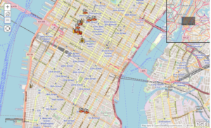
figure 1
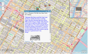
figure 2
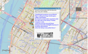
figure 3
You can see the published map (in progress) here:
https://www.arcgis.com/home/webmap/viewer.html?webmap=efb4c930dc214fa5a1692231a61d9093
Further remarks
- I deliberately marked those venues on the current Open Street Map (from ArcGIS) as I wanted to create the affirmatively haunting (albeit minor) topography and effects of those demolished places inside the current geography of Manhattan. Considering the “adult” quality of those venues, I wanted to mark them as X-X-X but I don’t know much about censorship on ArcGIS so I just used preset symbolized icons (cinemas, pubs, restaurants, etc.).
- Since maps like Google map and ArcGIS don’t have records of the addresses of the venues that disappeared in the process of Times Square Development Project, I had to manually find the addresses the old venues based on Delany’s descriptions and other archival information (newspapers and anecdotal notes by New Yorkers). Also, looking at old movies that filmed the Manhattan streets from the 60s to the 90s was helpful to see whether Delany’s writing is based on the actual history.
- As I consider this a humanistic and literary project (though it intersects with the scholarship of film history), I used pop-ups to cite Samuel R. Delany’s writing and photographs in the book. Choosing most compelling (culturally, historically, and theoretically) remarks by Delany is painstaking and I’m still working on making this more interesting to the wider range of the audience.
- Speaking of usability, the pop-ups do not function smoothly, but it seems like I need to learn professional visualization programming separately.
- If I have a premier ArcGIS account, I’d add a layer of information regarding the current property prices of those marked addresses to demonstrate why subcultural businesses no longer can enter those districts.
I love your map and post, Hyemin. It really brings to life how much the Times Square area has changed and sets the loss of the adult/gay establishments at a personal level.
Adding the property prices is a great idea. It would be interesting to track the property values changing over time in relation to these places popping into, then out of, existence on a map. From Delaney’s comment about the Adonis, it sounds like evicting these businesses may have raised property values across the area, which then made the area unaffordable and entirely displaced the community/communities.
Vivid custom XXX icons would be cool and help the mapped locations stand out against the background of the map, but may draw unwanted Terms of Use attention to your map from Esri.
(The popups all worked fine for me. I viewed the map using Safari, in case that helps with any debugging).
Hi Hannah, thanks for the kind & helpful comment. Yes, I’d like to add the layer of real estate prices & changes in those districts in the future. For now, I’m trying to visualize Delany’s own text in a best way that I can handle. Good to know the pop-ups work fine on your Safari browser!